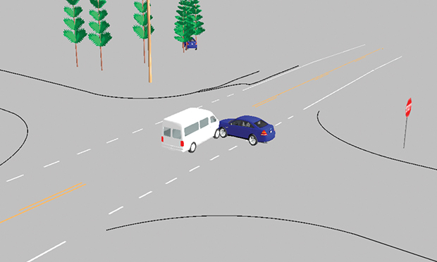
 While photographs show what happened following an accident, a diagram can show pre-collision movement. (Photo: The Warren Group)
When it comes to diagramming a crash scene, there are several methods to complete the task. Forensic mapping, (locating, positioning and documenting the evidence of a collision scene to scale) is essential to having the answers to the questions, "who, what, where, when and why." Photographs do a great job of showing what the investigators saw post-collision, yet they lack scale and the ability to describe pre-collision movement. Having a computer-aided diagram (CAD) of the collision scene goes much further than pictures can; here is why.
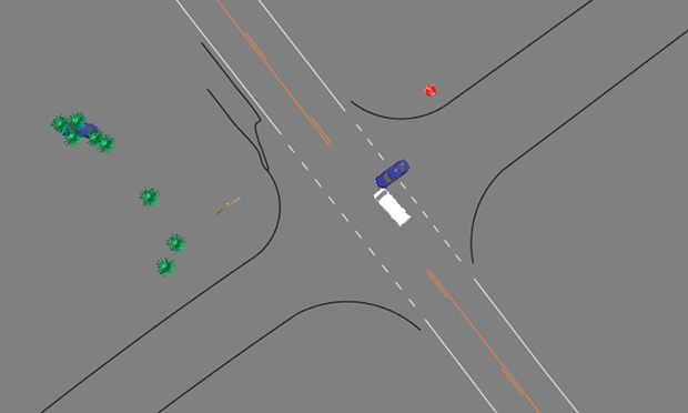 Figure 1. (Photo: The Warren Group)
A scale diagram (Figure 1) gives the full overview of a collision scene from either a 2D or 3D point of view. Being able to see how things lined up, how they came together and how they parted helps explain the events within a crash. When a scene can be viewed from top down or any angle, that helps relay the facts. The investigator, judge or jury will get a visual idea of what was happening up to, at and after impact.
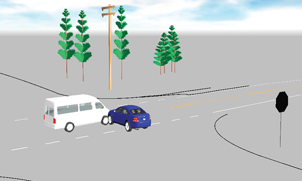 Figure 2. (Photo: The Warren Group)
Using properly documented physical evidence (Figure 2) in conjunction with the layout of the roadway in the area helps to tell the story from approach to final rest. Photographs limit the viewer to only seeing what was there in the aftermath and can also skew the perspective as to the position or distance captured within the frame.
Low-tech vs. high-tech
Using forensic mapping technology (a laser scanner, drone, total station or some other method of gathering data points for evidence) reduces time and adds detail that hand drawings lack. Gathering data by hand with a 100-foot tape measure takes time and being in the roadway is dangerous. The use of advanced technology reduces the time needed and simplifies the task of capturing the data as well as reduces the threat to an investigator.
To complete a CAD scale diagram, high-tech equipment is used to plot points throughout the crash site. For example, using the Sokkia Total Station, relevant points are mapped and coded by the investigator while the station relates each of them to its location. These points may be roadway lines, utility poles, skid marks, or any other item that helps to detail the scene or explain the collision.
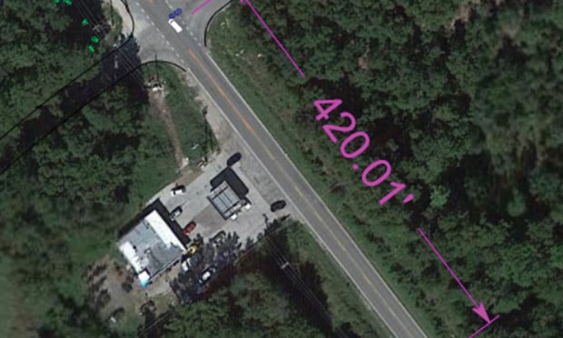 Figure 3. (Photo: The Warren Group)
By plotting and identifying each point, they can be brought into a computer program such as Faro Zone 3D and a scaled diagram can be completed (Figure 3). While a point was originally plotted from the station, measurements can be made from point-to-point or line-to-line. From the start to the finish of skids, or whatever distance, elevation or even grade you are trying to examine is available from the diagram. Now studies can be completed accurately and efficiently. The desired perspective can be produced to scale.
Once in the diagramming software, satellite maps may be imported into the mapped scene to help relate the collision data to the crash location. This makes the location more recognizable to the viewer by identifying buildings and other landscape details that are too vast to map. With the image being to scale and known measurements being taken by the investigator to relate to the satellite map, it is now possible to measure beyond the original mapped points. Time-distance calculations can be worked showing longer distances and, unlike a photograph, you can better relate distances and objects that relate to the investigation.
Technology has advanced and improved the way collision scenes are documented. When a crash scene is mapped, the collected data can be used to explain step-by-step what went on in a collision. The events can be shown stage by stage to explain how the collision happened, and the software allows answers to questions that may not have been thought about when the scene was being photographed or mapped. Investing in a scale diagram can reflect the happenings within a crash, showing the events of the collision as they unfolded.
Aaron Duncan II, ACTAR, ([email protected]) is a vehicle collision reconstructionist with The Warren Group, a forensic engineering and consulting firm with 25 years of collision investigation experience and knowledge of collision reconstruction.
Related:
Did that accident cause those injuries?
EDR imaging and claims: Putting the pieces together after a crash
This content has been archived. It is available through our partners, LexisNexis® and Bloomberg Law.
To view this content, please continue to their sites.
Not a Lexis Subscriber?
Subscribe Now
Not a Bloomberg Law Subscriber?
Subscribe Now
NOT FOR REPRINT
© 2025 ALM Global, LLC, All Rights Reserved. Request academic re-use from www.copyright.com. All other uses, submit a request to [email protected]. For more information visit Asset & Logo Licensing.
You Might Like
View AllTrending Stories
- 1Haynes and Boone Expands in New York With 7-Lawyer Seward & Kissel Fund Finance, Securitization Team
- 2Upstart Insurer That's Wowing Industry Hires AIG Legal Exec to Help Guide Global Expansion
- 3Connecticut Lawyers in Spotlight for Repping FBI Agents
- 4SEC Sued for Failing to Reveal Records Involving Simpson Thacher Attorney
- 5Lawsuit Accuses University of California of Racial Discrimination in Admissions
Who Got The Work
J. Brugh Lower of Gibbons has entered an appearance for industrial equipment supplier Devco Corporation in a pending trademark infringement lawsuit. The suit, accusing the defendant of selling knock-off Graco products, was filed Dec. 18 in New Jersey District Court by Rivkin Radler on behalf of Graco Inc. and Graco Minnesota. The case, assigned to U.S. District Judge Zahid N. Quraishi, is 3:24-cv-11294, Graco Inc. et al v. Devco Corporation.
Who Got The Work
Rebecca Maller-Stein and Kent A. Yalowitz of Arnold & Porter Kaye Scholer have entered their appearances for Hanaco Venture Capital and its executives, Lior Prosor and David Frankel, in a pending securities lawsuit. The action, filed on Dec. 24 in New York Southern District Court by Zell, Aron & Co. on behalf of Goldeneye Advisors, accuses the defendants of negligently and fraudulently managing the plaintiff's $1 million investment. The case, assigned to U.S. District Judge Vernon S. Broderick, is 1:24-cv-09918, Goldeneye Advisors, LLC v. Hanaco Venture Capital, Ltd. et al.
Who Got The Work
Attorneys from A&O Shearman has stepped in as defense counsel for Toronto-Dominion Bank and other defendants in a pending securities class action. The suit, filed Dec. 11 in New York Southern District Court by Bleichmar Fonti & Auld, accuses the defendants of concealing the bank's 'pervasive' deficiencies in regards to its compliance with the Bank Secrecy Act and the quality of its anti-money laundering controls. The case, assigned to U.S. District Judge Arun Subramanian, is 1:24-cv-09445, Gonzalez v. The Toronto-Dominion Bank et al.
Who Got The Work
Crown Castle International, a Pennsylvania company providing shared communications infrastructure, has turned to Luke D. Wolf of Gordon Rees Scully Mansukhani to fend off a pending breach-of-contract lawsuit. The court action, filed Nov. 25 in Michigan Eastern District Court by Hooper Hathaway PC on behalf of The Town Residences LLC, accuses Crown Castle of failing to transfer approximately $30,000 in utility payments from T-Mobile in breach of a roof-top lease and assignment agreement. The case, assigned to U.S. District Judge Susan K. Declercq, is 2:24-cv-13131, The Town Residences LLC v. T-Mobile US, Inc. et al.
Who Got The Work
Wilfred P. Coronato and Daniel M. Schwartz of McCarter & English have stepped in as defense counsel to Electrolux Home Products Inc. in a pending product liability lawsuit. The court action, filed Nov. 26 in New York Eastern District Court by Poulos Lopiccolo PC and Nagel Rice LLP on behalf of David Stern, alleges that the defendant's refrigerators’ drawers and shelving repeatedly break and fall apart within months after purchase. The case, assigned to U.S. District Judge Joan M. Azrack, is 2:24-cv-08204, Stern v. Electrolux Home Products, Inc.
Featured Firms
Law Offices of Gary Martin Hays & Associates, P.C.
(470) 294-1674
Law Offices of Mark E. Salomone
(857) 444-6468
Smith & Hassler
(713) 739-1250


