


Citizens Property Insurance Joins Center Providing Fast Disaster Imagery
Citizens joined the insurance industry consortium effort after testing it during Hurricane Irma.
May 14, 2019 at 03:06 PM
3 minute read

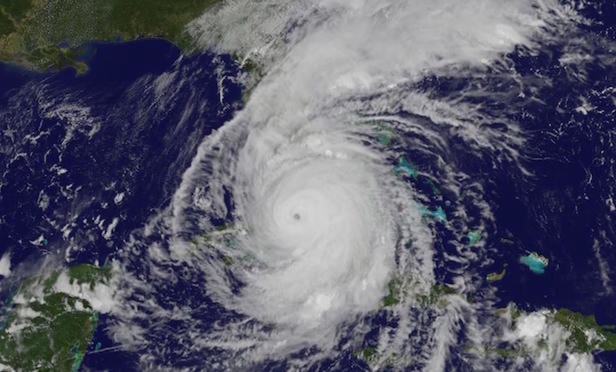 Hurricane Irma covers Florida
Florida's state-backed Citizens Property Insurance Corp. has joined the Geospatial Intelligence Center, an insurance industry consortium spearheaded by the National Insurance Crime Bureau.
In a statement, the NICB said that, as the GIC's newest member, Citizens now has access to advanced imagery and data to better serve its policyholders to expedite claims and improve fraud detection following a hurricane or other disaster.
The GIC combines the technical expertise of Vexcel Imaging, a photogrammetric and remote-sensing company, and Esri, which provides geographic information systems, to provide the tools and analytics to help insurers make decisions when writing a policy and dealing with disaster claims, according to the NICB.
In the days after a disaster, GIC aircraft fly over impacted areas to capture and assess damage to provide members with unprecedented imagery and data on impacted properties. The NICB, working with law enforcement and disaster scene commanders, has provided the center with access to disaster areas as soon as it is safe to fly. The center provides imagery and data to members within 24 to 36 hours of the aircraft touching down.
In 2017, Citizens tested the program after Hurricane Irma and sped up the claims process by several weeks. With the post-disaster survey-grade aerial imagery, Citizens was able to better identify high-damage areas, which helped with the placement of RVs and tents at Citizens response centers, the NICB noted.
“The GIC provides the technology needed to provide a fast assessment of damage in the aftermath of a disaster,” said NICB chief operating officer Jim Schweitzer. “We are proud that Citizens recognizes the value of getting quick access to disaster areas, particularly those affected by hurricanes in Florida, to better serve its policyholders and get them on the road to recovery faster.”
The bureay explained the center provides members with tools to compare before and after high-resolution imagery for catastrophic events such as hurricanes, tornadoes, floods, hailstorms, and wildfires.
The imagery is free to first responders and emergency personnel to allow them to better assess the extent of damages and coordinate their response. The bureau said the information also provides valuable evidence to help fight fraudulent claims, which are a frequent problem after catastrophes.
This content has been archived. It is available through our partners, LexisNexis® and Bloomberg Law.
To view this content, please continue to their sites.
Not a Lexis Subscriber?
Subscribe Now
Not a Bloomberg Law Subscriber?
Subscribe Now
NOT FOR REPRINT
© 2025 ALM Global, LLC, All Rights Reserved. Request academic re-use from www.copyright.com. All other uses, submit a request to [email protected]. For more information visit Asset & Logo Licensing.
You Might Like
View All

Once the LA Fires Are Extinguished, Expect the Litigation to Unfold for Years
5 minute read
Attorneys, Health Care Officials Face Nearly $80M RICO Suit Over Allegedly Fabricated Spreadsheet

Navigating Florida Property Insurance Claims in a Post-Fee-Shifting World
5 minute readTrending Stories
- 1Troutman Pepper, Claiming Ex-Associate's Firing Was Performance Related, Seeks Summary Judgment in Discrimination Suit
- 2Law Firm Fails to Get Punitive Damages From Ex-Client
- 3Over 700 Residents Near 2023 Derailment Sue Norfolk for More Damages
- 4Decision of the Day: Judge Sanctions Attorney for 'Frivolously' Claiming All Nine Personal Injury Categories in Motor Vehicle Case
- 5Second Judge Blocks Trump Federal Funding Freeze
Who Got The Work
J. Brugh Lower of Gibbons has entered an appearance for industrial equipment supplier Devco Corporation in a pending trademark infringement lawsuit. The suit, accusing the defendant of selling knock-off Graco products, was filed Dec. 18 in New Jersey District Court by Rivkin Radler on behalf of Graco Inc. and Graco Minnesota. The case, assigned to U.S. District Judge Zahid N. Quraishi, is 3:24-cv-11294, Graco Inc. et al v. Devco Corporation.
Who Got The Work
Rebecca Maller-Stein and Kent A. Yalowitz of Arnold & Porter Kaye Scholer have entered their appearances for Hanaco Venture Capital and its executives, Lior Prosor and David Frankel, in a pending securities lawsuit. The action, filed on Dec. 24 in New York Southern District Court by Zell, Aron & Co. on behalf of Goldeneye Advisors, accuses the defendants of negligently and fraudulently managing the plaintiff's $1 million investment. The case, assigned to U.S. District Judge Vernon S. Broderick, is 1:24-cv-09918, Goldeneye Advisors, LLC v. Hanaco Venture Capital, Ltd. et al.
Who Got The Work
Attorneys from A&O Shearman has stepped in as defense counsel for Toronto-Dominion Bank and other defendants in a pending securities class action. The suit, filed Dec. 11 in New York Southern District Court by Bleichmar Fonti & Auld, accuses the defendants of concealing the bank's 'pervasive' deficiencies in regards to its compliance with the Bank Secrecy Act and the quality of its anti-money laundering controls. The case, assigned to U.S. District Judge Arun Subramanian, is 1:24-cv-09445, Gonzalez v. The Toronto-Dominion Bank et al.
Who Got The Work
Crown Castle International, a Pennsylvania company providing shared communications infrastructure, has turned to Luke D. Wolf of Gordon Rees Scully Mansukhani to fend off a pending breach-of-contract lawsuit. The court action, filed Nov. 25 in Michigan Eastern District Court by Hooper Hathaway PC on behalf of The Town Residences LLC, accuses Crown Castle of failing to transfer approximately $30,000 in utility payments from T-Mobile in breach of a roof-top lease and assignment agreement. The case, assigned to U.S. District Judge Susan K. Declercq, is 2:24-cv-13131, The Town Residences LLC v. T-Mobile US, Inc. et al.
Who Got The Work
Wilfred P. Coronato and Daniel M. Schwartz of McCarter & English have stepped in as defense counsel to Electrolux Home Products Inc. in a pending product liability lawsuit. The court action, filed Nov. 26 in New York Eastern District Court by Poulos Lopiccolo PC and Nagel Rice LLP on behalf of David Stern, alleges that the defendant's refrigerators’ drawers and shelving repeatedly break and fall apart within months after purchase. The case, assigned to U.S. District Judge Joan M. Azrack, is 2:24-cv-08204, Stern v. Electrolux Home Products, Inc.

Featured Firms
Law Offices of Gary Martin Hays & Associates, P.C.
(470) 294-1674
Law Offices of Mark E. Salomone
(857) 444-6468
Smith & Hassler
(713) 739-1250