


Drones in the Legal Industry: Gaining the Higher Ground to Win Cases
The buzz around drones has swept the World. Their use in infrastructure inspection, cinematography and search and rescue are obvious, but can this technology be used in litigation to save money and ultimately win more cases?
October 25, 2018 at 02:30 PM
7 minute read

 The buzz around drones has swept the World. Their use in infrastructure inspection, cinematography and search and rescue are obvious, but can this technology be used in litigation to save money and ultimately win more cases?
Aerial Data and Litigation
Manned aircraft, satellite imagery, and now drones, are common platforms used to collect aerial data. The acquired imagery is often processed and analyzed with powerful software to uncover new insight and vantage points obtainable only from above.
For attorneys, aerial data can be used to focus research, craft strategies and create captivating exhibits.
Aerials have the unique ability to show both the big picture and then zoom in to show the important details. A map, aerial photograph or video can craft a viewer's perspective and provide a visual foundation of a site. More advanced products, like 3D models and multispectral imaging, reveal enlightening details not available in standard photographs and video.
Many Uses for Many Cases
Take, for example, a car crash. Imagine the typical, simple line drawings used by police and many attorneys. Visualizing and understanding the key factors and events that led to an accident using these crude exhibits can be extremely difficult for jurors and judges.
Now imagine presenting a high-resolution aerial image of the accident location. From that perspective, you “fly” into a photographic 3-D model of the site while crucial points are described and the view from each vehicle's location is recreated.
Jurors and decision makers “get it” because they can “see it.” You have built an immersive experience, not the typical bullet points and unpolished diagrams often used in the court room. Embracing tools like aerial photos and 3D models to inform jurors and judges could mean the difference between winning and losing.
Of course, not every case is suited to using aerial imagery. But for vehicular accidents, construction litigation, insurance disputes, environmental, eminent domain, maritime, aviation, and many others, aerials can help build a deeper understanding and illuminating exhibits that give you a significant advantage over the opposition.
The 'CSI Effect'
Many suggest that today's juries and decision makers are particularly swayed by high technology and sophisticated evidence in the courtroom. This is sometimes referred to as the “CSI Effect.” Drones and aerials perfectly fit this trend.
They have a certain wow factor and can demonstrate a commitment to pursue all the facts. Flying a site with a drone and producing persuasive exhibits in court can stick in the minds of jurors and create a memorable moment in court.
Manned aircraft have been used to create aerial images for decades. Now drones make aerials available and affordable for cases and budgets previously considered too small.
A professional drone can be purchased for orders of magnitude less than a manned airplane or helicopter. Additionally, manned aircraft require costly training, fuel, maintenance and pilots.
This is not to say that unmanned pilots should not have the proper experience or that drones do not require ongoing maintenance. These are important factors and must be considered. But, overall, everything is much less expensive.
The benefits of drones go far beyond just the cost. Drones can typically fly lower and closer to their subjects. This equates to sharper images, more accurate data and unique vantage points without the need to resort to extremely sophisticated and expensive imaging systems found in manned aircraft.
In a typical flight a drone may fly a grid pattern over a site to build a high-resolution map. Then the drone circles the site to fully photograph the location. Finally, it swoops in and around to capture compelling video. You get tremendous flexibility to find and present the details you need from a single mission.
Compelling Exhibits That Motivate Decision Makers
It is fun to watch a drone fly, but let's be honest, the value is in the data. This is where drones and advanced software combine to create game changing results.
Still photos and video are the staples of aerial imagery. Drones capture beautiful images using advanced cameras they can position relatively close to their subjects. And their rock-solid gimbals coupled with 4K recording capabilities produce dramatic, silky-smooth videos.
But, drones are by no means limited to still photos and video. Pairing advanced sensors like lidar and multi-spectral imagery with knowledgeable experts and consultants can lead to surprising discoveries and significant cost savings for cases.
Sharper, More Recent Maps Than Google Earth.
An autonomous drone will often take photos from dozens, or even hundreds, of points over a site. Specialized software is then used to merge the photos into a high-resolution map known as an orthomosaic.
The low fly height and stable camera of a drone creates maps that are sharper, more detailed, and certainly more recent, than most publicly available satellite data. Distances, angles and areas can be measured, often with accuracies of just a few centimeters.
Orthomosaics are typically geolocated meaning that their location on the Earth is encoded directly into the data. Click on a point in the map to verify the Latitude and Longitude of that location. Or import the entire orthomosaic into software like Google Earth.
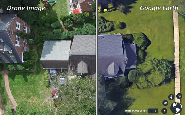
The entire process from acquisition to export is documented making admission and defense easier and more compelling. The benefits and potential savings for accident reconstruction, forensic investigations, environmental, oil and gas, and other potential litigation can be significant.
3D Models Provide Amazing Insight
But it gets better. Drone software can use photogrammetry techniques to determine the 3D location and distance between thousands of points in the images. The result is known as a point cloud. The software then builds lifelike virtual models by wrapping the actual photos over the point cloud.
The virtual models can be tilted, panned, zoomed and flown through by simply using a mouse and readily available software. The results are amazingly realistic and can cost a fraction of hand building a lower fidelity, animated 3D model. Elevation information, structure dimensions and volume are all calculated and output from the point cloud as well.
Use Early in Cases
Drone flights should not be limited to the end of the litigation cycle while preparing exhibits and prepping for trial.
In fact, flying a drone soon after an event or accident could potentially capture details that would otherwise be lost or destroyed. For the relatively low expense of flying a drone, one of the discoveries could ultimately prove instrumental to your case.
A Transformational Tool
Ultimately drones and aerial data can help you be more efficient, effective and successful in your cases. The true benefit lies in their ability to provide previously unseen insight and produce compelling and easily understood exhibits that focus and bolster your argument. They can also allow experts to find hidden facts and defend opinions.
Once considered a novelty, drones have grown into a robust tool that will gain popularity in the legal industry and give their proponents a leg up on the opposition.
Jeff Sassinsky is a commercial manned and unmanned aircraft pilot, the founder of Fovea Aero Systems, the creator of AerialExhibits.com and has a degree in Systems Engineering from The University of Pennsylvania.
This content has been archived. It is available through our partners, LexisNexis® and Bloomberg Law.
To view this content, please continue to their sites.
Not a Lexis Subscriber?
Subscribe Now
Not a Bloomberg Law Subscriber?
Subscribe Now
NOT FOR REPRINT
© 2025 ALM Global, LLC, All Rights Reserved. Request academic re-use from www.copyright.com. All other uses, submit a request to [email protected]. For more information visit Asset & Logo Licensing.
You Might Like
View All
‘Issue of First Impression’: New York Judge Clears Coinbase Appeal Amid Crypto Regulatory Clash
4 minute read
New York Times Moves for $100K in Attorney Fees Against Dfinity Foundation
3 minute read
Health Care Data Breach Class Actions Saw December Surge in NY Courts

Trending Stories
- 1AstraZeneca Files Flurry of Lawsuits to Protect Cancer Treatment Drug
- 2American Airlines Legal Chief Departs for Warner Bros. Discovery
- 3New Montgomery Bar President Aims to Boost Lawyer Referral Service
- 4Deadline Extended for Southeastern Legal Awards
- 5Church of Scientology Set to Depose Phila. Attorney in Sexual Abuse Case
Who Got The Work
Michael G. Bongiorno, Andrew Scott Dulberg and Elizabeth E. Driscoll from Wilmer Cutler Pickering Hale and Dorr have stepped in to represent Symbotic Inc., an A.I.-enabled technology platform that focuses on increasing supply chain efficiency, and other defendants in a pending shareholder derivative lawsuit. The case, filed Oct. 2 in Massachusetts District Court by the Brown Law Firm on behalf of Stephen Austen, accuses certain officers and directors of misleading investors in regard to Symbotic's potential for margin growth by failing to disclose that the company was not equipped to timely deploy its systems or manage expenses through project delays. The case, assigned to U.S. District Judge Nathaniel M. Gorton, is 1:24-cv-12522, Austen v. Cohen et al.
Who Got The Work
Edmund Polubinski and Marie Killmond of Davis Polk & Wardwell have entered appearances for data platform software development company MongoDB and other defendants in a pending shareholder derivative lawsuit. The action, filed Oct. 7 in New York Southern District Court by the Brown Law Firm, accuses the company's directors and/or officers of falsely expressing confidence in the company’s restructuring of its sales incentive plan and downplaying the severity of decreases in its upfront commitments. The case is 1:24-cv-07594, Roy v. Ittycheria et al.
Who Got The Work
Amy O. Bruchs and Kurt F. Ellison of Michael Best & Friedrich have entered appearances for Epic Systems Corp. in a pending employment discrimination lawsuit. The suit was filed Sept. 7 in Wisconsin Western District Court by Levine Eisberner LLC and Siri & Glimstad on behalf of a project manager who claims that he was wrongfully terminated after applying for a religious exemption to the defendant's COVID-19 vaccine mandate. The case, assigned to U.S. Magistrate Judge Anita Marie Boor, is 3:24-cv-00630, Secker, Nathan v. Epic Systems Corporation.
Who Got The Work
David X. Sullivan, Thomas J. Finn and Gregory A. Hall from McCarter & English have entered appearances for Sunrun Installation Services in a pending civil rights lawsuit. The complaint was filed Sept. 4 in Connecticut District Court by attorney Robert M. Berke on behalf of former employee George Edward Steins, who was arrested and charged with employing an unregistered home improvement salesperson. The complaint alleges that had Sunrun informed the Connecticut Department of Consumer Protection that the plaintiff's employment had ended in 2017 and that he no longer held Sunrun's home improvement contractor license, he would not have been hit with charges, which were dismissed in May 2024. The case, assigned to U.S. District Judge Jeffrey A. Meyer, is 3:24-cv-01423, Steins v. Sunrun, Inc. et al.
Who Got The Work
Greenberg Traurig shareholder Joshua L. Raskin has entered an appearance for boohoo.com UK Ltd. in a pending patent infringement lawsuit. The suit, filed Sept. 3 in Texas Eastern District Court by Rozier Hardt McDonough on behalf of Alto Dynamics, asserts five patents related to an online shopping platform. The case, assigned to U.S. District Judge Rodney Gilstrap, is 2:24-cv-00719, Alto Dynamics, LLC v. boohoo.com UK Limited.
Featured Firms
Law Offices of Gary Martin Hays & Associates, P.C.
(470) 294-1674
Law Offices of Mark E. Salomone
(857) 444-6468
Smith & Hassler
(713) 739-1250